
Page 330 - ALTA Endorsements Guide
P. 330
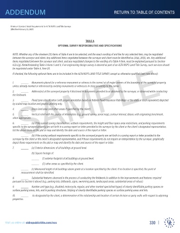
ADDENDUM                                                                  RETURN TO TABLE OF CONTENTS


        Minimum Standard Detail Requirements for ALTA/NSPS Land Title Surveys
        (Effective February 23, 2026)
                                                          TABLE A
                                       OPTIONAL SURVEY RESPONSIBILITIES AND SPECIFICATIONS


      NOTE: When any of the first twenty (20) items of Table A are selected, the exact wording of and fee for any selected item may be negotiated between the surveyor
      and client. Note that some items may be required by state statute, administrative rule or local ordinance in which case they must be included pursuant to Section
      3.B. Any additional items negotiated between the surveyor and client must be identified as 21(a), 21(b), etc. Any additional items negotiated between the surveyor
                SAMPLE
      and client, and any negotiated changes to the wording of a Table A item, must be explained pursuant to Section 6.D.ii.(g). Notwithstanding Table A Items 5 and 11,
      if an engineering design survey is desired as part of an ALTA/NSPS Land Title Survey, such services should be negotiated under Table A, Item 21.
      If checked, the following optional items are to be included in the ALTA/NSPS LAND TITLE SURVEY, except as otherwise qualified (see note above):


     1. _______ Monuments placed (or a reference monument or witness to the corner) at all major corners of the boundary of the surveyed property, unless already
               marked or referenced by existing monuments or witnesses in close proximity to the corner.
     2. _______ Address(es) of the surveyed property if disclosed in documents provided to or obtained by the surveyor, or observed while conducting the fieldwork.
     3. _______ Flood zone classification (with proper annotation based on federal Flood Insurance Rate Maps or the state or local equivalent) depicted by scaled map
               location and graphic plotting only.
     4. _______ Gross land area (and other areas if specified by the client).
     5. _______ Vertical relief with the source of information (e.g., ground survey, aerial map), contour interval, datum, with originating benchmark, when appropriate.
     6. _______ (a) If the current zoning classification, setback requirements, the height and floor spacearea restrictions, and parking requirements specific to the
               surveyed property are set forth in a zoning report or letter provided to the surveyor by the client or the client’s designated representative, list the
               above items on the plat or map and identify the date and source of the report or letter.
        _______ (b) If the zoning setback requirements specific to the surveyed property are set forth in a zoning report or letter provided to the surveyor by the
               client or the client’s designated representative, and if those requirements do not require an interpretation by the surveyor, graphically depict those
               requirements on the plat or map and identify the date and source of the report or letter.
     7. _______ (a) Exterior dimensions of all buildings at ground level.
               (b) Square footage of:
        _______     (1) exterior footprint of all buildings at ground level.
        _______     (2) other areas as specified by the client.
        _______ (c) Measured height of all buildings above grade at a location specified by the client. If no location is specified, the point of measurement shall be identified.
     8. _______ Substantial features observed in the process of conducting the fieldwork (in addition to the improvements and features required pursuant to Section 5
               above) (e.g., parking lots, billboards, signs, swimming pools, landscaped areas, substantial areas of refuse).
     9. _______ Number and type (e.g., disabled, motorcycle, regular, and other marked specialized types) of clearly identifiable parking spaces on surface parking
               areas, lots, and in parking structures. Striping of clearly identifiable parking spaces on surface parking areas and lots.
     10. _______ As designated by the client, a determination of the relationship and location of certain division or party walls with respect to adjoining properties.
     11.       Evidence of underground utilities existing on or serving the surveyed property (in addition to the observed evidence of utilities required pursuant to
               Section 5.E.iv.) as determined by:
        _______ (a) plans and/or reports provided by client (with reference as to the sources of information)
        _______ (b) markings coordinated by the surveyor or client pursuant to a private utility locate request.
               Note to the client, insurer, and lender – With regard to Table A, item 11, information from the sources checked above will be combined with observed
               evidence of utilities pursuant to Section 5.E.iv. to develop a view of the underground utilities. However, lacking excavation, the exact location of
               underground features cannot be accurately, completely, and reliably depicted. In addition, in some jurisdictions, 811 or other similar utility locate requests
               from surveyors may be ignored or result in an incomplete response, in which case the surveyor shall note on the plat or map how this affected the
               surveyor’s assessment of the location of the utilities. Where additional or more detailed information is required, the client is advised that excavation may be
               necessary.


                            ti
                              tl
                               e
                          l
                         b
                           c
                           i
                                      c
                                c
                                     n
     Visit us online at: oldrepublictitle.com/ncs s                                                    330
                                .
                                    /
                                 om
     V
               e a
        t u
       i
              n
          s o
            n
             li
      s
                   old
                     r
                      epu

      i
                 t
                  :